Esri Smarterworks

Esri SmarterWorks / SmarterWX
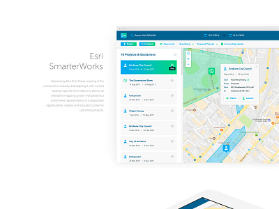
An intuitive, scalable cloud, location-specific interactive mapping tool enabling councils, government agencies and utilities to deliver smarter, faster and more efficient public works programs. SmarterWX allows collaborative opportunities, clashes and exclusion zones for upcoming projects.
One of the most enjoyable UX/UI projects I've had the pleasure of working on over the last 12 months. SmarterWorks, now branded SmarterWX, was a collaborative project run with Esri Australia Innovation Labs through JSA to develop a solution allowing multiple councils, public sectors and utility companies to share their upcoming works on public land.
Users of SmarterWX can see other planned works within defined areas and date ranges, and find opportunities to collaborate, reducing the need to disturb the public by running separate projects. Exclusion zones can also be created so that no public works are planned for important events around any location or major city (for example, fun runs, city street events etc.)
JSAcreative
https://www.smarterwx.com.au/
https://jsacreative.com.au/
http://aaronlepik.com/
User Experience Designer
User Interface Designer
Digital Designer