3D Interactive Geographical Exploration
As the Game Director and Project Manager, I am responsible for the end-to-end process, including defining the requirements, directing mechanics and art, and preparing administrative documents (MoUs, contracts, etc.).
Background
A GIS (Geographical Information System) provider company made a deal with Statistics Indonesia to create an immersive experience using their GIS.
Objective
To convert a traditional GIS into an interactive one by providing a 3D immersive exploration of Indonesia's geography with consistent and real-time data exchange.
Requirement Gathering
Mrs. 'S' - Senior Consultant of GIS Company
Mrs. 'S' is a senior consultant at the GIS company that provides the GIS program for Statistics Indonesia. She wants to create a 3D exploration that resembles a modern "game" with a 'futuristic' theme and real-time data passed through her API. She mentioned that the closest comparison she can imagine is something similar to Cities Skylines or SimCity.
Mr. 'A' - Senior of Statistics Indonesia Program
Mr. 'A' is the lead of the program. He feels that the current GIS serves data in a very traditional way (lots of tabular data and huge datasets), which is not very appealing. He wants to make it more interactive and improve the user experience without removing important data and information. He also prefers that the implementation be web-based so that the application does not require installation.
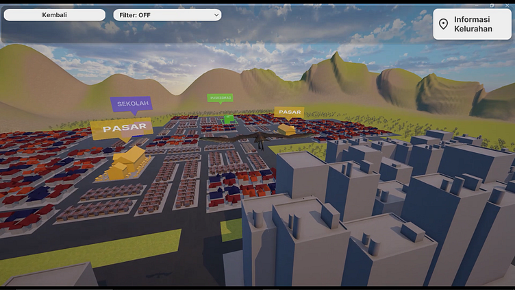
Solution
To deliver a Proof of Concept (POC) for our main objective, we chose a small Indonesian town and transformed it into a third-person view exploration of a Garuda (Indonesia's native eagle) using Unity 3D. This includes details on local poverty, prosperity, and public facilities, which users can filter within the application.
We opted for a desktop-based platform for the POC to expedite development before transitioning to a web-based platform.
