Map Modelling 3D
Hi!
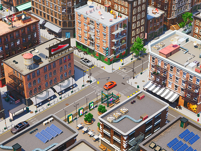
Do you also think that gray maps are boring, and all we need is some vibrance in them? For instance, you can show a 3D part of the city, and it would look much more believable than a simple map. That's what I did at Zajno. Just a simple example of how you can utilize this idea: to find a courier's route on a map. You don't need to follow a blue icon on gray traffic; instead, you watch a 3D city with a realistic car delivering your order. Besides, it can be used in city modeling: from realistic streets to a futuristic neighborhood with flying cars and a hologram of WiFi waves diverging from poles.
To begin with, I decided on the place to navigate through. I'm a fan of New York streets, so I did the first work with a hint of this particular city: old Brooklyn. I took its streets as the primary reference for my work and familiarized myself with its infrastructure and the location of the buildings.
Having collected a mood board where I placed various buildings and decor elements, I started modeling the buildings themselves. However, the most challenging was the creation of the Brooklyn atmosphere. I researched all the details: the location of the benches, types of equipment used to create the infrastructure, and similar information helping enliven the visualization.
After that, I downloaded several models of lacking sceneries and adjusted them to my style.
The materials and rendering setup were the most considerable work because each task required extraordinary attention to detail. Each building is unique with its assets, and this meticulous process is very addictive.
Are you excited to see the continuation of the city? Share in the comments!
Website |Join our Newsletter! |Crappy Explanation Playlists App |TheGrid |Spotify |Twitter |Medium |Facebook|Instagram