GIS - optimization for transport, logistics and route networks


We - The Flexatel team - work extensively in the field of optimization for transport, logistics and route networks, where implementing GIS is the natural choice. Our developers and GIS specialists have completed several projects that provide solutions for various types of transportation. One recent example is a geographic information system which increases the efficiency of urban passenger transport usage.
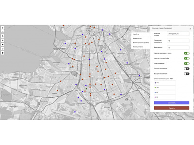
The goal of the project was to create an interactive portal that builds user itineraries and calculates optimal timetables using urban transport route networks. The portal offers route network options, while also allowing users to choose station stops and get a preliminary calculation of the schedule and required transport. The system has algorithms for calculating schedules with a given number of vehicles on the route. External data sources on population density, commercial facilities, office buildings and the like can be incorporated into the portal.
The system currently uses up-to-date data and maps, including graphs of 50 cities in Russia and the CIS.
The portal’s wide range of features allows users to:
• Lay routes according to the current road network graph
• Calculate schedules with an assigned number of vehicles on the route
• Change departure time through graphic interface
• Add stops, end stations, and bus fleets
• Set general parameters of the route network and vehicles
• Update the road network graph
• Download reports, tables, graphs
• Control user access through multi-user interface
