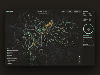
Cycling infrastructure metrics
Starting my first post here in Dribbble with this exploration for the next version of CicloMapa, a web app I designed and built to make bike maps in Brazil more collaborative and accessible.
I've always loved designing map-based apps, and with this new version, I'm being able to blend it with another passion of mine: analytics!
Leveraging OpenStreetMap, the "Wikipedia of maps", we're now being able to show more data than ever. The platform dynamically calculates metrics such as length of cycleways and a total number of points-of-interest (bike parking, shops, stations), but also combines with qualitative indicators such as People Near Bikes (by ITDP) and IdeCiclo (by AmeCiclo).
__
I'm a very technical designer & developer looking for improving my visual design chops, so all CC very appreciated!
→ Read the case study: https://cristianodalbem.com/ciclomapa/
→ See it live: https://ciclomapa.org.br
