CurieuzeNeuzen Vlaanderen 2018 - Data Map
This is a shot from a project I did back in 2018 when I was working for De Standaard, one of the leading newspapers in Belgium.
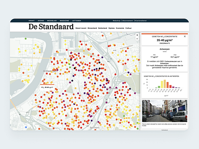
I designed and built an interactive map with 20.000 data points spread over the cities, towns, and countryside of Flanders mapping the air pollution created by cars. Visitors could search for the dot on the street for their house, their parents’ and their children’s school.
On launch day only, 650.000 unique visitors spent 1 million minutes on this map. Making it the most visited application in the publisher's digital history and eventually resulting in winning a 'Belfius Persprijs' in the category of Digital Press.
