Covid 19 Cases NYC on March 9, 2020
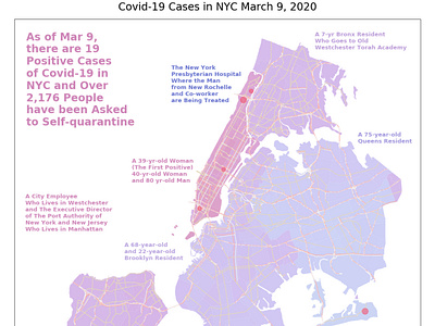
Based on news sources such as The New York State Department of Health, The New York Times, The Wall Street Journal, Business Insider, Patch.com, Spectrum NY1, The Gothamnist and AMNY, I have gathered relevant data regarding the Covid-19 virus and plotted them on a map of NYC.
To create the map, I sourced geographical shape files from the NYC Open Data Portal — specifically ones with zip codes to map out the NYC neighborhoods and truck route data to display some major roads to help NYC residents orient themselves.
If you are interested in working on visualizing the data, please find my notebook: https://bit.ly/3czMUD7
