3D Flight Planner Mission Types
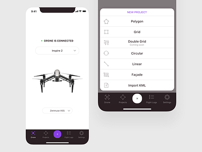
Here’s the onboarding flow of Tap2Map. The first step in any land surveying activity is to make sure the app is connected to the drone. Next, you’d choose out of the 6 flight plan modes the one that suited you best. You can also upload a pre-planned flight path as an XML file, if you’re the type of surveyor that did their homework at a desktop workstation.
Follow us as we share more screens for this awesome product. We’re not done yet.
_
If you like our shot, press "L" to show it some love!
See more of our work on our website and follow us for more product insights.
We’re a product studio committed to building the kind of apps people love to use and we’d love to help you with your next challenge. Get in touch!
